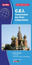
CIS | Commonwealth of Independent States | BERLITZ
£6.95
Stock Status: In Stock
Description
Description
This large scale road and tourist map covers the whole of the Commonwealth of Independent States, and parts of the surrounding countries. The map shows a wealth of information with the road network clearly differentiated by colour and road numbers and intermediate driving distances given. Towns and cities are marked together with railways, airports and ferry routes and country boundaries are clearly shown as well as time zone boundaries. The map includes relief shading to indicate terrain and shows spot heights, rivers, mountain ranges, national parks and a selection of camp sites and places of interest.
The reverse of the map features a large overview map of the area shown at 1:15,000,000 and distance chart together with a comprehensive place names index and street plans of
Legend: French, English, German
| ISBN/EAN | 978 1 85879 6819 |
|---|---|
| Scale | 1: 3,500,000 |
| Format | Folded Map |
| Publisher | Berlitz |


Reviews
There are no reviews yet.